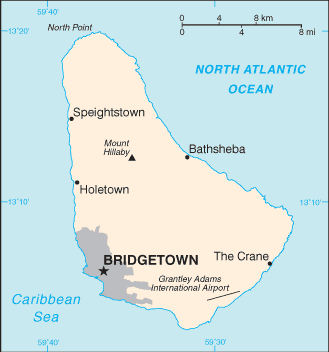
Map of Barbados


Map of Barbados

Map of Barbados


Barbados is located in the Caribbean. It is an island in the North Atlantic Ocean, northeast of Venezuela. This island has an area of 430 square kilometer. The capital of Barbados is Bridgetown.

Barbados has 11 parishes and 1 city*; Bridgetown*, Christ Church, Saint Andrew, Saint George, Saint James, Saint John, Saint Joseph, Saint Lucy, Saint Michael, Saint Peter, Saint Philip, and Saint Thomas.

English
Caribbean Countries | Caribbean Map | Barbados Flag

Español
Paises del Caribe | Mapa del Caribe | Bandera de Barbados | Mapa de Barbados


Sources
https://www.cia.gov/library/publications/the-world-factbook/geos/bb.html
https://www.cia.gov/library/publications/the-world-factbook/maps/maptemplate_bb.html

Other tags used are map Barbados, maps Barbados, Barbados map, and maps of Barbados.


Return from map of Barbados to facts about of Barbados

Return to Caribbean countries


Enjoy this page? Please pay it forward. Here's how...

Would you prefer to share this page with others by linking to it?

  1. Click on the HTML link code below.
  2. Copy and paste it, adding a note of your own, into your blog, a Web page, forums, a blog comment, your Facebook account, or anywhere that someone would find this page valuable.


Make Money with Clickbank


Medford, Oregon, United States


Central Point, Oregon, United States


Grants Pass, Oregon, United States


Crater Lake National Park, Oregon, United States