|
|
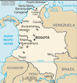
Colombian Map
 Mapa de Colombia Colombian Map Mapa de Colombia Colombian Map
Colombia is located in the Northern part of South America, bordering the Caribbean Sea, between Panama and Venezuela, and bordering the North Pacific Ocean, between Ecuador and Panama.Colombia has 32 departments and they are listed below:
Amazonas (Leticia), Antioquia (Medellín), Arauca (Arauca), Atlántico (Barranquilla), Bolivar (Cartagena (Colombia), Boyacá (Tunja), Caldas (Manizales), Caquetá (Florencia), Casanare (Yopal), Cauca (Popayan), Cesar (Valledupar), Chocó (Quibdo), Córdoba (Monteria), Cundinamarca (Bogotá), Guainía (Puerto, Inirida), La Guajira (Riohaca), Guaviare (San Jose del Guaviare), Huila (Neiva), Magdalena (Santa Marta), Meta (Villavicencio), Nariño (Pasto), Norte de Santander (Cucuta), Putumayo(Mocoa), Quindío (Armenia), Risaralda (Pereira), San Andres y Providencia (Departamento) (San Andrés), Santander (Bucaramanga), Sucre (Sincelejo), Tolima (Ibagué), Valle del Cauca (Cali), Vaupés (Mitú), y Vichada (Puerto Carreño).
Sources
http://geology.com/world/colombia-satellite-image.shtml
https://www.cia.gov/library/publications/the-world-factbook/geos/co.html Other tags used are Colombia map, map of Colombia, maps Colombia, and map Colombia.
Return colombian map to facts about colombia
Return to the home page
Enjoy this page? Please pay it forward. Here's how...
Would you prefer to share this page with others by linking to it?
- Click on the HTML link code below.
- Copy and paste it, adding a note of your own, into your blog, a Web page, forums, a blog comment,
your Facebook account, or anywhere that someone would find this page valuable.
|
|
Make Money with Clickbank
Medford, Oregon, United States
Central Point, Oregon, United States
Grants Pass, Oregon, United States
Crater Lake National Park, Oregon, United States
|


