Tennessee County Map


Tennessee County Map

Tennessee County Map

The map of Tennessee is wide and there is not enough room within the page to make it larger unless the map is placed sideways. The names of the counties are hard to read because they are very small. What you can do to read them is to point the mouse on the map and right click. Then click on view image. Once on the next page, you will be able to read them because the letters show a little more clear.

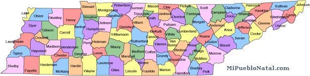
Tennessee has 95 counties. The largest county of Tennessee county Shelby County with an area 755 square miles. The smallest county is Lake county and covers 210 square miles.

See a list of counties in Tennessee


If you are from Tennessee and would like to write about your home town, just click on the county where your city is located and write about it. (Coming soon)

Comments


Return from Tennessee county map to facts about Minnesota

Return to the United States main page


Other keywords used are Tennessee counties map, county map Tennessee, map Tennessee counties, and tn map.

Enjoy this page? Please pay it forward. Here's how...

Would you prefer to share this page with others by linking to it?

  1. Click on the HTML link code below.
  2. Copy and paste it, adding a note of your own, into your blog, a Web page, forums, a blog comment, your Facebook account, or anywhere that someone would find this page valuable.


Medford, Oregon, United States


Central Point, Oregon, United States


Grants Pass, Oregon, United States


Crater Lake National Park, Oregon, United States