[?]Subscribete a esta paginas web


|
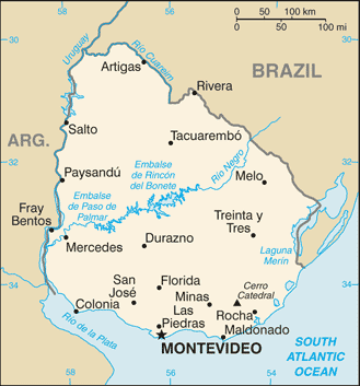
Map of UruguayMap of Uruguay Uruguay is located in Southern South America, bordering the South Atlantic Ocean, between Argentina and Brazil. Its borders are with Argentina and Brazil. The capital of Uruguay is Montevideo. Uruguay has 19 departments; Artigas, Canelones, Cerro Largo, Colonia, Durazno, Flores, Florida, Lavalleja, Maldonado, Montevideo, Paysandu, Rio Negro, Rivera, Rocha, Salto, San Jose, Soriano, Tacuarembo, Treinta y Tres.
Retur from map of uruguay to facts about uruguay
|


Medford, Oregon, United States

Central Point, Oregon, United States

Grants Pass, Oregon, United States

Crater Lake National Park, Oregon, United States