[?]Subscribete a esta paginas web


|
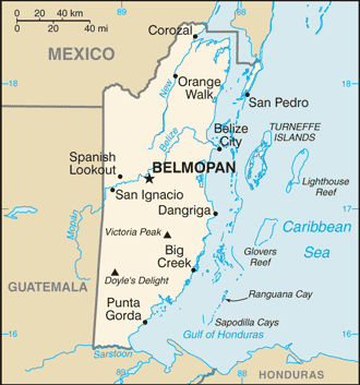
Map of Belize
Belize has borders with Guatemala which is about 266 kilometers in length and Mexico about 250 kilometers in length. Belize is located in Central America, bordering the Caribbean Sea, between Guatemala and Mexico. Its capital is Belmopan. Belize is slightly smaller than Massachusetts. Belize has 6 districts; Belize, Cayo, Corozal, Orange Walk, Stann Creek, and Toledo. Belize became independent from the United Kingdom in September 21, 1981. Its independence day is celebrated on this date.
Return from map of belize to facts about belize
|


Medford, Oregon, United States

Central Point, Oregon, United States

Grants Pass, Oregon, United States

Crater Lake National Park, Oregon, United States