Honduras Map
Map of Honduras
Flag of Honduras Bandera de Honduras Mapa de Honduras
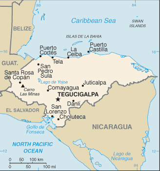
Honduras is located in Central America, bordering the Caribbean Sea, between Guatemala and Nicaragua and bordering the Gulf of Fonseca (North Pacific Ocean), between El Salvador and Nicaragua. Its borders are with Guatemala, El Salvador, and Nicaragua. Honduras has 18 departments: Atlantida, Choluteca, Colon, Comayagua, Copan, Cortes, El Paraiso, Francisco Morazan, Gracias a Dios, Intibuca, Islas de la Bahia, La Paz, Lempira, Ocotepeque, Olancho, Santa Barbara, Valle, Yoro. The capital of Honduras is Tegucigalpa.
Sources
https://www.cia.gov/library/publications/the-world-factbook/geos/ho.html
https://www.cia.gov/library/publications/the-world-factbook/maps/maptemplate_ho.html
Other keywords used are map of Honduras, map Honduras, y maps Honduras.
Return from honduras map to honduras
Return to the home page
Enjoy this page? Please pay it forward. Here's how...
Would you prefer to share this page with others by linking to it?
- Click on the HTML link code below.
- Copy and paste it, adding a note of your own, into your blog, a Web page, forums, a blog comment,
your Facebook account, or anywhere that someone would find this page valuable.
|


