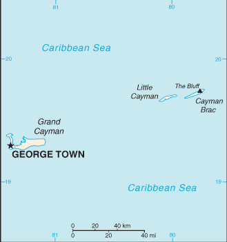
Cayman Islands Map


Cayman Islands Map

Cayman Islands Map


The Cayman islands is comprised by three islands (Grand Cayman, Cayman Brac, Little Cayman) and are located in the Caribbean Sea, 240 km south of Cuba and 268 km northwest of Jamaica.

These Islands have 8 districts and they are; Creek, Eastern, Midland, South Town, Spot Bay, Stake Bay, West End, and Western.

English
Caribbean Countries | Caribbean Map | Cayman Islands Flag

Español
Paises del Caribe | Mapa del Caribe | Islas Cayman Banderas | Islas Cayman Mapa


Sources
https://www.cia.gov/library/publications/the-world-factbook/geos/bb.html
https://www.cia.gov/library/publications/the-world-factbook/maps/maptemplate_bb.html

Other tags used are map Cayman Islands, and map of Cayman Islands.


Return from Cayman Islands map to Cayman Islands facts

Return to Caribbean countries


Enjoy this page? Please pay it forward. Here's how...

Would you prefer to share this page with others by linking to it?

  1. Click on the HTML link code below.
  2. Copy and paste it, adding a note of your own, into your blog, a Web page, forums, a blog comment, your Facebook account, or anywhere that someone would find this page valuable.


Make Money with Clickbank


Medford, Oregon, United States


Central Point, Oregon, United States


Grants Pass, Oregon, United States


Crater Lake National Park, Oregon, United States