|
|
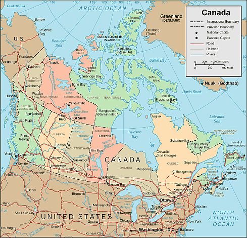
Canada Map
Canadian Flag Bandera de Canada mapa de Canada
Canadian Map
Canada is located in the northern area of North America, bordering the North Atlantic Ocean on the east, North Pacific Ocean on the west, and the Arctic Ocean on the north, north of the conterminous United States. Canada is the second largest country in world (after Russia).Canada has 10 provinces and 3 territories. The capital city is in parenthesis:
Alberta (Edmonton)
British Columbia (Victoria)
Prince Edward Island (Charlottetown)
Manitoba (Winnipeg)
New Brunswick (Fredericton)
Nova Scotia (Halifax)
Nunavut (Iqaluit)
Ontario (Toronto)
Quebec (Quebec City)
Saskatchewan (Regina)
Newfoundland (St. John's)
Northwest Territories (Yellowknife)
Yukon Territory (Whitehorse)
Sources
https://www.cia.gov/library/publications/the-world-factbook/geos/ca.html
Sources
http://geology.com/world/colombia-satellite-image.shtml
http://www.studyvec.com/facts-about-canada/
Other tags used are map of Canada, maps of Canada.
Return from canada map to facts about canada
Return to the home page
Enjoy this page? Please pay it forward. Here's how...
Would you prefer to share this page with others by linking to it?
- Click on the HTML link code below.
- Copy and paste it, adding a note of your own, into your blog, a Web page, forums, a blog comment,
your Facebook account, or anywhere that someone would find this page valuable.
|
|
Make Money with Clickbank
Medford, Oregon, United States
Central Point, Oregon, United States
Grants Pass, Oregon, United States
Crater Lake National Park, Oregon, United States
|


