


|
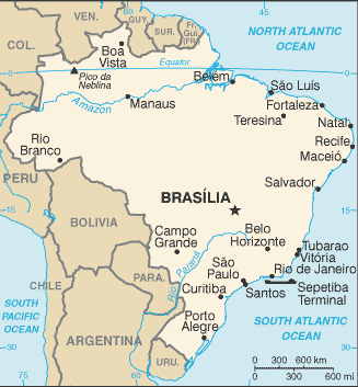
Map of BrazilMap of Brazil Brazil is located in Eastern South America, bordering the Atlantic Ocean. Its borders are with Argentina, Bolivia, Colombia, French Guiana, Guyana, Paraguay, Peru, Suriname, Uruguay, and Venezuela. The capital of Brazil is Brasilia. Brazil has 26 states and 1 federal district*; Acre, Alagoas, Amapa, Amazonas, Bahia, Ceara, Distrito Federal*, Espirito Santo, Goias, Maranhao, Mato Grosso, Mato Grosso do Sul, Minas Gerais, Para, Paraiba, Parana, Pernambuco, Piaui, Rio de Janeiro, Rio Grande do Norte, Rio Grande do Sul, Rondonia, Roraima, Santa Catarina, Sao Paulo, Sergipe, Tocantins
Return from map of brazil to facts about brazil
|


Medford, Oregon, United States

Central Point, Oregon, United States

Grants Pass, Oregon, United States

Crater Lake National Park, Oregon, United States