


|
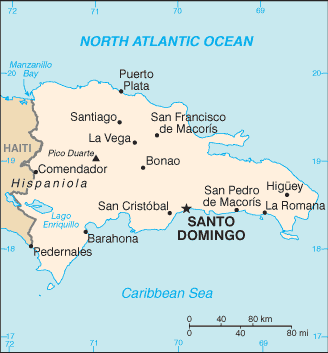
Dominican Republic Map
The Dominican Republic is located in the Caribbean. It is eastern two-thirds of the island of Hispaniola, between the Caribbean Sea and the North Atlantic Ocean, east of Haiti. The Dominican Republic is divided into 31 provinces and 1 district*; Azua, Bahoruco, Barahona, Dajabon, Distrito Nacional*, Duarte, El Seibo, Elias Pina, Espaillat, Hato Mayor, Independencia, La Altagracia, La Romana, La Vega, Maria Trinidad Sanchez, Monsenor Nouel, Monte Cristi, Monte Plata, Pedernales, Peravia, Puerto Plata, Salcedo, Samana, San Cristobal, San Jose de Ocoa, San Juan, San Pedro de Macoris, Sanchez Ramirez, Santiago, Santiago Rodriguez, Santo Domingo, and Valverde. Other keywords used are Republic Dominican map, Dominican map, and map of Dominican.
Return from Dominican Republic map to Dominican Republic facts
|


Medford, Oregon, United States

Central Point, Oregon, United States

Grants Pass, Oregon, United States

Crater Lake National Park, Oregon, United States