[?]Subscribete a esta paginas web


|
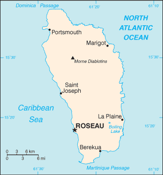
Dominica Map
The island of Dominica is located in the Caribbean. This island is between the Caribbean Sea and the North Atlantic Ocean, about half way between Puerto Rico and Trinidad and Tobago. Dominica is divided into 10 parishes and the are: Dominica has 10 parishes; Saint Andrew, Saint David, Saint George, Saint John, Saint Joseph, Saint Luke, Saint Mark, Saint Patrick, Saint Paul, and Saint Peter. English Caribbean Countries | Caribbean Map | Dominica Flag Español Paises del Caribe | Mapa del Caribe | Bandera Dominica | Mapa de Dominica Sources https://www.cia.gov/library/publications/the-world-factbook/flags/flagtemplate_do.html Other tags used are Dominique maps, map Dominica, and map of Dominica.
Return from Dominica Map to facts about Dominica
|


Medford, Oregon, United States

Central Point, Oregon, United States

Grants Pass, Oregon, United States

Crater Lake National Park, Oregon, United States