[?]Subscribete a esta paginas web


|
Map of ArubaMap of Aruba 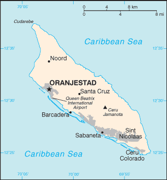 Aruba is and island located in the Caribbean Sea, 15 miles off the north of Venezuela. The island is 19.6 miles long and 6 miles across at its widest point, with a total area of approximately 70 square miles. The capital of Aruba is Oranjestad. Aruba is a member country of the Kingdom of the Netherlands;. English Caribbean Countries Caribbean Map Aruba Flag Español Paises del Caribe Mapa del Caribe Bandera de Aruba Mapa de Aruba Sources https://www.cia.gov/library/publications/the-world-factbook/geos/aa.html https://www.cia.gov/library/publications/the-world-factbook/maps/maptemplate_aa.html http://www.aruba.com/ExploretheIsland/maps.aspx Other tags used are Aruba map, Aruba maps, maps of Aruba, and map Aruba.
Regresar de map of Aruba to Aruba facts
|


Medford, Oregon, United States

Central Point, Oregon, United States

Grants Pass, Oregon, United States

Crater Lake National Park, Oregon, United States