Minnesota County Map
Minnesota County Map
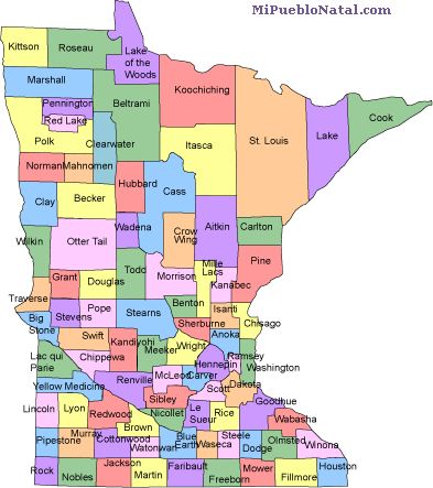
Minnesota has 87 counties. The largest one by size is St. Louis county with an area of 6,226 square miles. The smallest one is Ramsey county with an area of 156 square miles. The counties in Minnesota are listed below:
* Aitkin * Anoka * Becker * Beltrami * Benton * Big * Stone * Blue * Earth * Brown * Carlton * Carver * Cass * Chippewa * Chisago * Clay * Clearwater * Cook * Cottonwood * Crow * Wing * Dakota * Dodge * Douglas * Faribault * Fillmore * Freeborn * Goodhue * Grant * Hennepin * Houston * Hubbard * Isanti * Itasca * Jackson * Kanabec * Kandiyohi * Kittson * Koochiching * Lac * qui * Parle * Lake * Lake of the * Woods * Le * Sueur * Lincoln * Lyon * Mahnomen * Marshall * Martin * McLeod * Meeker * Mille * Lacs * Morrison * Mower * Murray * Nicollet * Nobles * Norman * Olmsted * Otter * Tail * Pennington * Pine * Pipestone * Polk * Pope * Ramsey * Red * Lake * Redwood * Renville * Rice * Rock * Roseau * Scott * Sherburne * Sibley * St. * Louis * Stearns * Steele * Stevens * Swift * Todd * Traverse * Wabasha * Wadena * Waseca * Washington * Watonwan * Wilkin * Winona * Wright * Yellow * Medicine *
If you are from Minnesota and would like to write about your home town, just click on the county where your city is located and write about it. (Coming soon) Comments
Return from Minnesota county map to facts about Minnesota
Return to the United States main page
Other keywords used are county map Minnesota, Minnesotta counties map and mn map.
Enjoy this page? Please pay it forward. Here's how...
Would you prefer to share this page with others by linking to it?
- Click on the HTML link code below.
- Copy and paste it, adding a note of your own, into your blog, a Web page, forums, a blog comment,
your Facebook account, or anywhere that someone would find this page valuable.
|