Michigan County Map
Michigan County Map
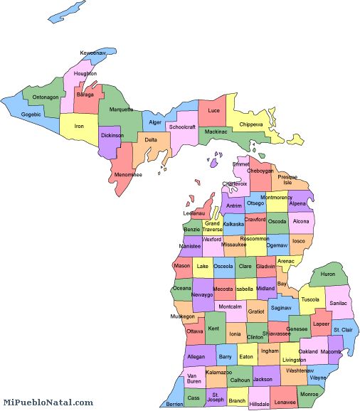
Michigan has a total of 83 counties. As you can see on the map, Marquette county is the largest county in Michigan and has a pulation of about 64,000. The smallest one is hard to tell but the is Benzie County which measures 316 square miles and has a population of almost 16,000. Benzies's seat is Beulah. The counties in Michigan are listed below:
* Alcona * Alger * Allegan * Alpena * Antrim * Arenac * Baraga * Barry * Bay * Benzie * Berrien * Branch * Calhoun * Cass * Charlevoix * Cheboygan * Chippewa * Clare * Clinton * Crawford * Delta * Dickinson * Eaton * Emmet * Genesee * Gladwin * Gogebic * Grand Traverse * Gratiot * Hillsdale * Houghton * Huron * Ingham * Ionia * Iosco * Iron * Isabella * Jackson * Kalamazoo * Kalkaska * Kent * Keweenaw * Lake * Lapeer * Leelanau * Lenawee * Livingston * Luce * Mackinac * Macomb * Manistee * Marquette * Mason * Mecosta * Menominee * Midland * Missaukee *Monroe * Montcalm * Montmorency * Muskegon * Newaygo * Oakland * Oceana * Ogemaw * Ontonagon * Osceola * Oscoda * Otsego * Ottawa * Presque Isle * Roscommon * Saginaw * Sanilac * Schoolcraft * Shiawassee * St. Clair * St. Joseph * Tuscola * Van Buren * Washtenaw * Wayne * Wexford *
If you are from Michigan and would like to write about your home town, just click on the county where your city is located and write about it. (Coming soon) Comments
Return from Michigan county map to facts about Michigan
Return to the United States main page
Other keyword used are alabama maps and map alabama.
Enjoy this page? Please pay it forward. Here's how...
Would you prefer to share this page with others by linking to it?
- Click on the HTML link code below.
- Copy and paste it, adding a note of your own, into your blog, a Web page, forums, a blog comment,
your Facebook account, or anywhere that someone would find this page valuable.
|