


|
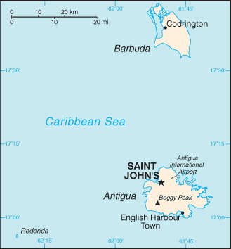
Map of Antigua
Antigua and Barbuda islands are in the Caribbean. They are between the Caribbean Sea and the North Atlantic Ocean, east-southeast of Puerto Rico. To the south are the islands of Montserrat and Guadalupe, and to the north and west are Nevis, St. Kitts, St. Barts, and St. Martin. Antigua is about 14 miles long and 11 miles wide which has a total of 108 square miles. Barbuda has an area of 68 square miles and it is about 30 miles north of Antigua. Other tags used are Antigua map, Antigua maps, maps of Antigua, and map Antigua.
Return from map of Antigua to Antigua information
|


Medford, Oregon, United States

Central Point, Oregon, United States

Grants Pass, Oregon, United States

Crater Lake National Park, Oregon, United States