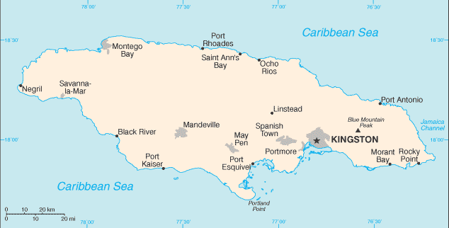
Home
World Countries
Productos
Canada
United States
Mexico
Guatemala
Honduras
Belice
El Salvador
Nicaragua
Costa Rica
Panama
Caribbean Countries
Colombia
Ecuador
Peru
Venezuela
Bolivia
Guyana
Chile
Argentina
Brazil
Uruguay
Paraguay
MiPueblo Blog
Directorio
Clasificados
Importante
Famous People
Chistes
Copa Mundial
$$$$
Salud Y Mas
Travel Links
Red Social
Germany
Advertise With Us
Terms of Service
About Me
Testimonios
American Lighthouses

Subscribete a esta paginas web
XML RSS
Add to Google
Add to My Yahoo!
Add to My MSN
Subscribe with Bloglines

Jamaican Map


Jamaican Map

Jamaican Map


Jamaica is the third largest island in the Caribbean. This island is located south of Cuba. It is 235 kilometers long and 56 kilometers wide. It has a total area of 10,991 square kilometers.

Jamaica is divided into 14 parishes; Clarendon, Hanover, Kingston, Manchester, Portland, Saint Andrew, Saint Ann, Saint Catherine, Saint Elizabeth, Saint James, Saint Mary, Saint Thomas, Trelawny, and Westmoreland.

English
Caribbean Countries | Caribbean Map | Jamaican Flag

Español
Paises del Caribe | Mapa del Caribe | Bandera de Jamaica | Mapa de Jamaica


Sources
https://www.cia.gov/library/publications/the-world-factbook/geos/jm.html
https://www.cia.gov/library/publications/the-world-factbook/maps/maptemplate_jm.html
http://www.britannica.com/EBchecked/topic/299716/Jamaica

Other tags used are map jamaica, jamaica maps, maps jamaica, and jamaica map.


Return from Jamaican Map to Jamaica facts

Return to Caribbean countries


Work on the Internet

Cheap tickets

Netflix Movies


Medford, Oregon, United States


Central Point, Oregon, United States


Grants Pass, Oregon, United States


Crater Lake National Park, Oregon, United States