[?]Subscribete a esta paginas web


|
Antigua Information - Antigua And Barbuda Information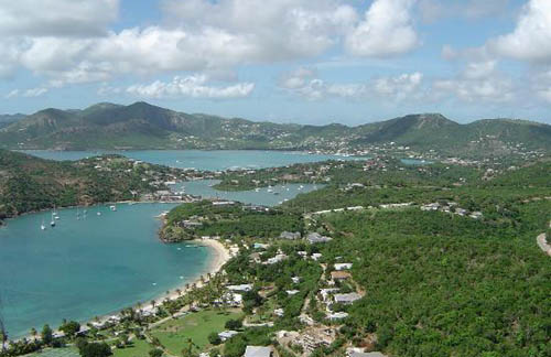 Antigua Information Antigua and Barbuda (2 islands) are located in the Caribbean, islands between the Caribbean Sea and the North Atlantic Ocean, east-southeast of Puerto Rico. tourism, construction, light manufacturing (clothing, alcohol, household appliances). Agriculture: cotton, fruits, vegetables, bananas, coconuts, cucumbers, mangoes, sugarcane; livestock. Antigua and Barbuda is divided into 6 parishes and 2 dependencies*; Barbuda*, Redonda*, Saint George, Saint John, Saint Mary, Saint Paul, Saint Peter, Saint Philip Saint John's (Saint John), All Saints, Liberta (Saint Paul), Bolans (Saint Mary), Potters Village (Saint John), Parham (Saint Peter), Carlisle (Saint George), Cedar Grove (Saint John), Swetes (Saint Paul), Codrington (Barbuda) English Caribbean Countries Caribbean Map Antigua Flag Map of Antigua Español Paises del Caribe Mapa del Caribe Bandera de Antigua Mapa de Antigua Sources https://www.cia.gov/library/publications/the-world-factbook/geos/ac.html http://www.state.gov/r/pa/ei/bgn/2336.htm http://www.geonames.org/AG/largest-cities-in-antigua-and-barbuda.html http://sobrecaribe.com/2008/09/28/islas-leeward-en-las-pequenas-antillas/ (picture above) Other keywords used are facts Antigua, Antigua island, Antigua info, and Antigua islands. Return from Antigua information to the Caribean countries
|


Medford, Oregon, United States

Central Point, Oregon, United States

Grants Pass, Oregon, United States

Crater Lake National Park, Oregon, United States